Sprectrum Location Intelligence Module
Enable smarter business decisions with Location Intelligence.
Enable smarter business decisions with Location Intelligence
Gain highly accurate location-based insights designed to fuel better business performance. Benefit from powerful address geocoding and efficient enterprise routing.
Reduce risk and improve both operations and customer satisfaction.
Transform location insights into intelligence
Improve planning
Visualize opportunities. Understand risks.
Inform decision-making
Increase precision. Enrich insight.
Boost operational efficiency
Automate analysis. Streamline results.
Increase savings.
Reduce waste. Reduce wasted effort.
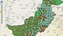
Interactive mapping and spatial analysis
Rapidly create interactive mapping and spatial analysis web sites using rich internet application (RIA) user interface components and web services (SOAP, REST, OGC).
Deliver powerful applications for public internet, partner and corporate intranet web sites, with support for mapping for visualization and analysis, comprehensive spatial query and geometry calculations.
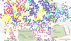
Analytical mapping visualization
Use the extensive range of analytical mapping visualization in Spectrum to successfully communicate a clear common operational picture. Integrate mapping and spatial analysis into business systems such as Business Intelligence (BI), Enterprise Intelligence (EI), Customer Relationship Management (CRM), Enterprise Resource Planning (ERP) and supervisory control and data acquisition (SCADA) to improve decision making.
The Spectrum Spatial Location Intelligence Module allows you to increase efficiency through spatially enabling business analysts existing working environment, and reducing the reliance on scarce GIS analyst resources.
Operational Location Intelligence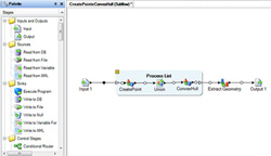
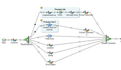
Use Operational Location Intelligence to deliver efficiency improvements and apply spatial intelligence directly within human-free, straight through processes and automated business decisions. Operational Location Intelligence enables spatial business rules and logic to be embedded within operational systems and frees the organization from costly overheads of manual spatial analysis processes in workflows. By reducing manual analysis workloads to exception handling only, business rules are applied more consistently and faster decisions can be made in support of real time responses.
The Location Intelligence module provides support for visual point-click design of data flows for operational location intelligence, decreasing the time to value and increasing the flexibility to rapidly adapt the logic and rules to changes in business.
Integrate business data with GIS data
Bring business data and GIS data together using built in spatially enabled visual data integration, enabling organizations to rapidly expose the value of hidden location with their data assets. Integrate data in GIS formats and spatial databases with business data in XML files, web services and RDBMS, removing domain data silos and simplifying the spatially enabled IT organization. Transform business data from multiple systems to build spatial databases. Create data flows for batch and web service based transaction data integration.
Use spatial data integration to augment business databases with spatially derived data values extending the value of spatial intelligence to more difficult to access systems.
Build geospatial application databases to support interactive mapping and spatial analysis applications for web and desktop clients.
Interoperability
Share maps and data through certified Open Geospatial Consortium (OGC) Services for web mapping (WMS), feature (WFS) and cataloguing (CSW). Reuse the same data and maps via SOAP and REST interfaces to support integration with other IT systems and middleware enabling both IT and GIS trained resources to access spatial capability.
Part of the Spectrum Platform
The Location Intelligence Module is part of the Spectrum platform. As such it can be used with any of the modules in the platform and shares a common management and flow design environment simplifying administration.
The Location intelligence module is part of the Spectrum Platform Spatial Solution encompassing the Location Intelligence Module, Enterprise Routing Module, Enterprise Geocoding Module and GeoTex Module. In addition to spatial capability a broad range of business data quality and management capability is available.
Spatial Capability
- Access spatial capability via RIA controls, Web Services (SOAP, REST, OGC) and Data Flows
- Mapping
- Generate maps including cartographic, aerial and analytical mapping
- Generate legends
- Tile Maps
- Generate map tiles from business or base mapping data
- Utilize built in caching to deliver high performance seamless maps user experience
- Feature Query
- Query features from any data source(s) using spatially enabled MapInfo SQL (SQL 92 MM)
- Rich SQL support (SQL 92 MM) including comprehensive WHERE clause, grouping, sorting, joins and 100 functions
- Built in paging support
- Geometry Operations
- Measure Geometries (length, area, perimeter, distance)
- Transform Geometries between coordinate reference systems
- Manipulate Geometries (Buffer, Convex Hull, Envelop, Intersection, Union, Difference, Symmetric Difference)
- Determine Geometry Relationships – (Contains, Envelopes Intersect, intersects, Within (including point in polygon), Equals, Validate)
-
-
-
- Cataloguing – geographical metadata cataloguing including discovery and management
-
-
User Defined Logic Services (Data Flows) – use transactional data integration to create spatially enabled logical web services and batches.
Administration
- Enterprise Designer – Visual drag and drop flow diagramming style designer to create data flows for transactional and batch data integration.
- Management Console – Administer users and permissions, manage server content and data, manage server and service configuration and logging.
- Administration APIs – user and permissions management and server content management.
Security
-
-
-
- Secure web services and content
- Support for SSL
-
-
RIA Controls and Javascript API
-
-
-
- Rapidly integrate location intelligence and mapping functionality within applications
- Display business data over popular base mapping services such as Google Maps and Bing Maps
- Consume and display OGC WMS and WFS services.
- Out of the Box User Interface Controls:
- Map Control (Open Layers 2.10) – visualize and interact with data via the map
- Layer/Legend Control – Display available layers and control their visibility
- Templating for Feature Service Results – bind the results from feature services into tables, grids, lists and much more
- Pure Javascript/HTML/CSS thin client technology
-
-
Web Services
-
-
-
- Build spatially enabled applications
- Integrate spatial logic into business processes
- Support for developer and interoperability focused web service interfaces:
- SOAP (WS-I Compliant)
- REST
- OGC Web Services (Certified)
- SDK support for .Net and Java.
-
-
Data Integration
-
-
-
- Integrate spatial data with business data using a visual data design tools
- Integrate within databases, web services, file and XML data sources
- Prepare spatial databases
- Rapidly build location data integration and augmentation processes
- Publish data flows as transactional web services (SOAP/REST)
- Publish batch data integration (scheduled and watch folder)
- Compatible with all Spectrum Technology Platform Spatial, Data Integration and Data Quality Modules
-
-
Data Packs
-
-
-
- MapInfo Street Pro data packs are available
- Spectrum Spatial Location Intelligence Module is compatible with Pitney Bowes data products.
-
-
Certified OGC Web Services
-
-
-
- Web Map Services 1.1.1 & 1.3
- Web Feature Services 1.0
- Catalogue Services For Web 2.0.2
-
-
Supported Data Sources
-
-
-
- Web Map Services 1.1.1 & 1.3
- Oracle 10g & 11g (locator only required)
- Microsoft SQL Server 2008
- PostGIS 1.5.2
- XY Tables (JDBC)
- Non Spatial Tables (JDBC)
- MapInfo TAB File
- ESRI Shape file
- Autodesk SQLite FDO
- Raster Formats (ECW, MrSID, GIF, JPEG/JPEG 2000, TIF, PNG, BMP)
- Grid Formats (NTIF, MapInfo Grid, Northwood Grid, DTED, CADRG, ADRG, CIB)
- Cartographic Text (MapInfo TAB File, Autodesk TextTable*)
- Custom Data Sources – Data Provider SDK
-
-
Supported Browsers
-
-
-
- Microsoft Internet Explorer 8 & 9
- Mozilla Firefox 10 & 11
- Google Chrome 17 & 18
- Safari 5 (Mac OSX only)
-
-
Supported Operating Systems
-
-
-
- Microsoft Internet Explorer 8 & 9
- Microsoft Windows Server 2003 & 2008 (32bit and 64bit)
- SUSE Linux 10 & 11 (32bit & 64bit)
- Red Hat Enterprise Linux 5 & 6 (32bit & 64bit)
- Oracle Solaris 9 & 10
- HP-UX v11iV3 (Itanium)
- AIX 6.1, 7.1
-
-
*Oracle and Autodesk SQLite FDO only